
Державною установою «Держгідрографія» та Державною службою морського та річкового транспорту України проведено оцінку ефективності системи розподілу руху №2. Підходи до портів Чорноморськ, Одеса та Південний (СРР).
За результатами виконаних робіт
підготовлено пропозиції щодо внесення змін до СРР з метою їх подальшого подання для прийняття ІМО.
Метою змін є встановлення границь СРР в межах існуючої схеми руху суден, спрощення руху суден системою, підвищення рівня безпеки, усунення невідповідностей між СРР, діючою на національному рівні, і СРР, прийнятими ІМО 22.04.1981 (COLREG.2/Circ.14), та актуалізація таких даних як назва СРР, нумерація і назви частин СРР, використовувані морські навігаційні карти та система координат.


Короткий огляд.
Відповідно до підготовлених пропозицій пропонується схвалити на міжнародному рівні СРР Підходи до портів Чорноморськ, Одеса та Південний, що складається із семи частин, тим самим поєднати 2 прийняті ІМО системи в одну та прийняти на міжнародному рівні частини VI у напрямку порту Південний та VII, що є районом підвищеної обережності плавання на підходах до порту Південний, що дозволить здійснювати розподіл зустрічних потоків суден на підходах до портів Чорноморськ, Одеса та Південний, а також у напрямку портів Миколаївського регіону (що також прямують частинами VI і VII СРР) з метою зменшення вірогідності зіткнення суден. Запровадження частини VII – району підвищеної обережності плавання на підходах до порту Південний – необхідне, оскільки в даному районі сходяться потоки суден, що прямують з порту Одеса до портів Миколаївського регіону.

Також пропонується внести зміни до частини ІІ СРР шляхом
зміни району
колового руху на район підвищеної обережності плавання у визначених координатах.
Аналіз інтенсивності руху суден за даними АІС свідчить, що район колового руху
в його існуючих межах не використовується суднами повною мірою, а колова зона
розподілу руху радіусом 1 миля в центрі надто велика і є певною перешкодою для
руху суден. Запровадження району підвищеної обережності плавання та зменшення колової
зони розподілу руху до 0,5 милі дасть змогу спростити курс суден та встановити
границі Частини ІІ СРР в межах існуючої схеми руху суден.
За пропозицією Служби регулювання
руху суден Філії «Дельта-лоцман» ДП «АМПУ» у частині І СРР пропонується розширити
смуги руху за рахунок зменшення зони розподілу руху. Так, ширина зони розподілу
руху зменшується з 2 миль до 1,4 милі, ширина смуг руху збільшується з 0,9 милі
до 1,2 милі. Такі зміни збільшують простір для маневрування суден, що прямують
з різними швидкостями (від 10 до 22 вузлів) у напрямку до портів (з портів)
Чорноморськ, Одеса, Південний. Водночас зміни в частині І відповідатимуть
змінам, що пропонуються в частині ІІ СРР, а саме – зменшенню кругової зони
розподілу руху.
Також буде актуалізовано інформацію
щодо назви СРР, нумерації її частин, назв портів, системи координат.
СРР № 2. Підходи до
портів Чорноморськ, Одеса та Південний призначена для всіх типів суден та
вантажів.
Таким чином, запропоновані зміни до СРР виправлять застарілу, неактуальну інформацію про діючу систему установлення шляхів у регіоні прийняту Комітетом з безпеки на морі ІМО 22.04.1981. Зміни дозволять модернізувати СРР встановивши її границі в межах існуючих потоків руху суден, дозволять спростити навігацію системою оскільки буде зменшена кількість змін курсу судном, яке прямує системою, що у свою чергу підвищить безпеку мореплавства та захист навколишнього середовища.
Детальний опис та географічні координати проекту зміненої СРР № 2 «Підходи до портів Чорноморськ, Одеса та Південний»
Примітка: Система координат – всесвітня геодезична система
1984 року (WGS 84).
Опис зміненої системи
розподілу руху
Система
складається із семи частин.
Частина I (мориста)
Зона розподілу
руху, обмежена лініями, що з’єднують точки:
1) 46°07.74’N, 031°05,27’E;
2) 46°13.32’N, 030°57.55’E;
3) 46°14.32’N, 030°59.05’E;
4) 46°08.74’N, 031°06.77’E.
Ширина зони розподілу
руху – 1,4 милі.
Зовнішня межа смуги
руху в порти Чорноморськ, Одеса та Південний проходить через точки:
5) 46°09.51’N, 031°07.92’E;
6) 46°15.09’N; 031°00.21’E.
Встановлений напрямок
потоку руху – 316,5°.
Зовнішня межа смуги
руху із портів Чорноморськ, Одеса та Південний проходить через точки:
7) 46°12.55’N, 030°56.39’E;
8) 46°06.97’N, 031°04.11’E.
Встановлений напрямок потоку руху – 136,5°.
Частина II Район підвищеної обережності
плавання
Район підвищеної
обережності плавання включає колову зону розподілу
руху радіусом 0,5 милі
з центром у точці 9) 46°15.50’N, 030°56.27’E,
обмежений лініями, що з’єднують точки:
6) 46°15.09’N; 031°00.21’E;
7) 46°12.55’N, 030°56.39’E;
17) 46°15.89’N; 030°50.95’E;
14) 46°17.49’N, 030°51.70’E;
28) 46°17.99’N, 030°52.40’E;
25) 46°18.89’N, 030°54.50’E;
36) 46°19.06’N, 030°55.09’E;
33) 46°18.99’N, 030°57.25’E.
Встановлений напрямок
потоку руху – проти годинникової стрілки навколо колової зони розподілу руху.
Частина III Підхід до порту Чорноморськ
Зона розподілу руху,
обмежена лініями, що з’єднують точки:
10) 46°16.45’N, 030°51.21’E;
11) 46°17.76’N, 030°45.59’E;
12) 46°18.21’N, 030°45.90’E;
13) 46°16.92’N, 030°51.43’E.
Ширина зони розподілу
руху – 0,5 милі.
Зовнішня межа смуги
руху в порт Чорноморськ проходить через точки:
14) 46°17.49’N, 030°51.70’E;
15) 46°18.79’N, 030°46.30’E.
Встановлений напрямок потоку
руху – 288°.
Зовнішня межа смуги
руху із порту Чорноморськ проходить через точки:
16) 46°17.19’N, 030°45.20’E;
17) 46°15.89’N; 030°50.95’E.
Встановлений напрямок
потоку руху – 108°.
Частина IV Від порту Одеса до порту Чорноморськ.
Включає дві смуги руху
і лінію розподілу руху, яка проходить через точки:
18) 46°27.27’N, 030°48.41’E;
19) 46°21.89’N, 030°47.35’E;
20) 46°19.09’N, 030°44.74’E.
Ширина смуг руху з обох
сторін від лінії розподілу руху – по 2,5 кбт.
Встановлені напрямки
потоків руху: 188° та 212,8° (з Одеси в Чорноморськ) та 32,8° і 8° (з
Чорноморська в Одесу).
Частина V Підхід до порту Одеса
Включає дві смуги руху
та зону розподілу руху, обмежену лініями, що з’єднують точки:
21) 46°18.29’N, 030°53.10’E;
22) 46°27.69’N, 030°49.86’E;
23) 46°27.69’N, 030°50.61’E;
24) 46°18.57’N, 030°53.75’E.
Ширина зони розподілу
руху – 5 кбт.
Зовнішня межа смуги
руху в порт Одеса проходить через точки:
25) 46°18.89’N, 030°54.50’E;
26) 46°27.69’N, 030°51.50’E.
Встановлений напрямок
потоку руху – 346,5°.
Зовнішня межа смуги
руху із порту Одеса проходить через точки:
27) 46°27.69’N, 030°49.10’E;
28) 46°17.99’N, 030°52.40’E.
Встановлений напрямок
потоку руху – 166,5°.
Частина VI Підходи до порту Південний
Включає дві смуги руху
та зону розподілу руху, обмежену лініями, що з’єднують точки:
29) 46°19.04’N, 030°55.80’E;
30) 46°31.55’N, 030°55.65’E;
31) 46°31.73’N, 030°56.37’E;
32) 46°19.02’N, 030°56.52’E.
Ширина зони розподілу
руху – 5 кбт.
Зовнішня межа смуги
руху в північному напрямку проходить через точки:
33) 46°18.99’N, 030°57.25’E;
34) 46°31.89’N, 030°57.04’E.
Встановлений напрямок
потоку руху – 359,5°.
Зовнішня межа смуги
руху в південному напрямку проходить через точки:
35) 46°31.36’N, 030°54.90’E;
36) 46°19.06’N, 030°55.09’E.
Встановлений напрямок
потоку руху – 179,5°.
Частина VII Район підвищеної обережності
плавання
Район обмежений
лініями, що з’єднують точки:
35) 46°31.36’N, 030°54.90’E;
37) 46°32.50’N, 030°54.90’E;
38) 46°33.16’N, 030°57.62’E;
39) 46°32.04’N, 030°57.62’E.

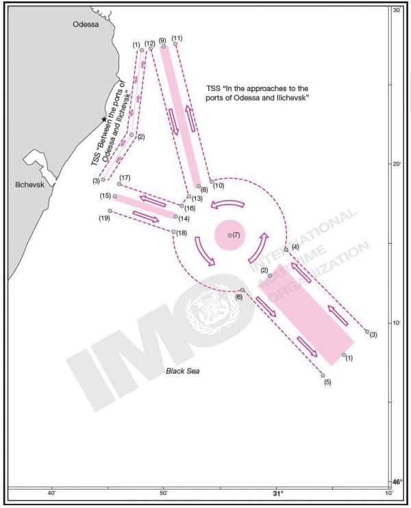
Proposals have been drafted to amend the Traffic Separation Scheme (TSS) No 2. In the Approaches to the Chornomorsk, Odesa and Pivdennyi Ports
The State Hydrographic Service of Ukraine (SHSU) and the State Service for Maritime and River Transport of Ukraine have conducted the evaluation of efficiency of TSS No 2. Approaches to the Chornomorsk, Odesa and Pivdennyi Ports.
Proposals for making changes to the TSS have been drafted on the basis
of work performed with a view to their further submission for adoption by the
International Maritime Organization (IMO).
The purpose of the changes is to establish the boundaries of the TSS within the existing scheme of vessel traffic, simplify the vessel traffic by means of this system, increase the safety level, eliminate inconsistencies between the TSS operating at the national level and the TSS adopted by the IMO on 22.04.1981 (COLREG.2/Circ.14), and update the data – such as the name of the TSS, numbers and names of its parts, the nautical charts and the datum involved.


Summary
In accordance with the drafted proposals, it is suggested to adopt at the international level the TSS ‘Approaches to the Chornomorsk, Odesa and Pivdennyi Ports’ consisting of 7 parts, and thereby to combine 2 previously adopted by the IMO systems into one system and approve at the international level Part VI towards the Pivdennyi Port and Part VII, which is a precautionary area on the approaches to the Pivdennyi Port. Assuming such measures will allow to segregate the opposing flows of the vessel traffic on the approaches to the Chornomorsk, Odesa and Pivdennyi Ports, as well as to the ports of the Mykolaiv Region (applicable to the vessels navigating by Part VI and Part VII of the TSS), aiming to decrease the probability of vessels collisions. The introduction of Part VII – the precautionary area on the approaches to the Pivdennyi Port, is essential, as the traffic flows of vessels cruising from the Odesa Port to the ports of the Mykolaiv Region converge in this area.

Part II of the TSS is also proposed to be
amended by changing the roundabout traffic zone by
the precautionary area within defined end limits. The analysis of vessel
traffic density according to the AIS data shows that the roundabout traffic
zone within its existing boundaries is not used by vessels in full, while the roundabout
traffic zone with a radius of 1 m in the centre is too large and creates
certain obstacles for the traffic. The introduction of the precautionary area
and shortening of the roundabout traffic zone radius to 0.5 miles will
make it possible to simplify the vessels’ course and establish the boundaries
of Part II of the TSS within the existing traffic pattern.
The VTS of the State Enterprise ‘Ukrainian Sea Ports Authority’ (SE
USPA) Pilotage Branch – Delta Pilot has suggested to expand the traffic lanes
in Part I of the TSS by reducing the separation
zone width. Thus, the width of the traffic separation zone decreases from 2 miles
to 1.4 miles, and the width of traffic lanes increases from 0.9 miles
to 1.2 miles. Such changes increase the manoeuvring space for the vessels
steering with different speeds (from 10 to 22 knots) in directions to/from the Chornomorsk,
Odesa and Pivdennyi Ports. At the same time, the amendments to Part I will
correspond to the amendments proposed to Part II of the TSS, namely, the
reduction of the roundabout traffic zone.
Information about the name of the TSS, its parts’ numbers, ports’ names,
datum will be also updated.
TSS No 2. Approaches to the Chornomorsk, Odesa and Pivdennyi Ports is designed for all types of vessels and cargoes. Thus, the proposed changes to the TSS will actualize the outdated information on the existing routeing system in the region, as adopted by the IMO Maritime Safety Committee on 22.04.1981. The amendments will modernize the TSS by establishing its boundaries within the existing traffic flows limits and simplify the navigation within the system, as it will lessen the number of changes of course by the vessels steering within the system. Therefore, the safety of navigation and protection of environment levels will be boosted.
Detailed description and geographical coordinates of the proposed TSS No 2. – Approaches to the Chornomorsk, Odesa and Pivdennyi Ports
Note: The
used datum is the World Geodetic System 1984 (WGS84)
Description of the amended traffic separation system
The system
consists of seven parts.
Part I (seaward)
The
traffic separation zone is limited by lines connecting the following geographical
positions, –
1) 46°07.74’N, 031°05.27’E;
2) 46°13.32’N, 030°57.55’E;
3) 46°14.32’N, 030°59.05’E;
4) 46°08.74’N, 031°06.77’E.
Traffic
separation zone width – 1.4 miles.
The outer
edge of the traffic lane to the Chornomorsk, Odesa and Pivdennyi Ports passes
through the geographical positions, –
5)
46°09.51’N, 031°07.92’E;
6)
46°15.09’N; 031°00.21’E.
The established
traffic flow direction – 316.5°.
The outer
edge of the traffic lane from the Chornomorsk, Odesa and Pivdennyi Ports passes
through the geographical positions, –
7)
46°12.55’N, 030°56.39’E;
8)
46°06.97’N, 031°04.11’E.
Established traffic flow direction – 136.5°.
Part
II. Precautionary area
The precautionary area includes the roundabout traffic separation zone, 0.5 miles radius, centre
in position 9) 46°15.50′ N, 030°56.27′ Е, and is limited by lines connecting
the following geographical positions, –
6)
46°15.09’N; 031°00.21’E.
7)
46°12.55’N, 030°56.39’E;
17)
46°15.89’N; 030°50.95’E;
14)
46°17.49’N, 030°51.70’E;
28)
46°17.99’N, 030°52.40’E;
25)
46°18.89’N; 030°54.50’E;
36)
46°19.06’N; 030°55.09’E;
33)
46°18.99’N; 030°57.25’E.
The established
traffic flow direction is counter-clockwise, around the roundabout traffic
separation zone.
Part
III. Approaches to the Chornomorsk Port
The
traffic separation zone is limited by lines connecting the following geographical
positions, –
10)
46°16.45’N; 030°51.21’E;
11)
46°17.76’N; 030°45.59’E;
12)
46°18.21’N; 030°45.90’E;
13)
46°16.92’N; 030°51.43’E.
Traffic
separation zone width – 0.5 miles.
The outer
edge of the traffic lane to the Chornomorsk Port passes through the geographical
positions, –
14)
46°17.49’N, 030°51.70’E;
15)
46°18.79’N; 030°46.30’E.
The established
traffic flow direction – 288°.
The outer
edge of the traffic lane from the Chornomorsk Port passes through the geographical
positions, –
16)
46°17.19’N; 030°45.20’E;
17)
46°15.89’N; 030°50.95’E.
The established
traffic flow direction – 108°.
Part
IV. From the Odesa Port to the Chornomorsk Port
It
includes two traffic lanes with a traffic separation line in between, its axis passes
through the geographical positions, –
18)
46°27.27’N; 030°48.41’E;
19)
46°21.89’N; 030°47.35’E;
20)
46°19.09’N; 030°44.74’E.
Traffic
lanes width – 2.5 cables from each side of the traffic separation line.
The established
traffic flows direction – 188° and
212.8° (from Odesa to Chornomorsk); 32.8° and 8° (from Chornomorsk to Odesa).
Part V.
Approach to the Odesa Port
It
includes two traffic lanes with a traffic separation zone that is limited by
lines connecting the following geographical positions, –
21)
46°18.29’N; 030°53.10’E;
22)
46°27.69’N; 030°49.86’E;
23)
46°27.69’N; 030°50.61’E;
24)
46°18.57’N; 030°53.75’E.
Traffic
separation zone width – 5 cables.
The outer
edge of the traffic lane to the Odesa Port passes through the geographical positions,
–
25)
46°18.89’N; 030°54.50’E;
26)
46°27.69’N; 030°51.50’E.
The established
traffic flow direction – 346.5°.
The outer
edge of the traffic lane from the Odesa Port passes through the geographical positions,
–
27)
46°27.69’N; 030°49.10’E;
28)
46°17.99’N, 030°52.40’E.
The established
traffic flow direction – 166.5°.
Part
VI. Approaches to the Pivdennyi Port
It
includes two traffic lanes with a traffic separation zone that is limited by
lines connecting the following geographical positions –
29)
46°19.04’N; 030°55.80’E;
30)
46°31.55’N; 030°55.65’E;
31)
46°31.73’N; 030°56.37’E;
32)
46°19.02’N; 030°56.52’E.
Traffic
separation zone width – 5 cables.
The outer
edge of the traffic lane passes northwards through the geographical positions,
–
33)
46°18.99’N; 030°57.25’E;
34)
46°31.89’N; 030°57.04’E.
The established
traffic flow direction – 359.5°.
The outer
edge of the traffic lane passes southwards through the geographical positions,
–
35)
46°31.36′ N, 030°54.90′ E
36)
46°19.06’N; 030°55.09′ E.
The established
traffic flow direction – 179.5°.
Part
VII. Precautionary area
The area
is limited by lines connecting the following geographical positions, –
35)
46°31.36′ N, 030°54.90′ E
37)
46°32.50′ N, 030°54.90′ E
38) 46°33.16′ N, 030°57.62′ E
39) 46°32.04′ N, 030°57.62′ E.

Повідомляє Держгідрографія.